BladeRunner
Дрыщ, очкарик, задрот, ботан, на мамкиной шее
Often when they write how scary everything is and how much there is to do, there is actually a simple and quick solution. for example, maybe "offset".
Посмотрите видео ниже, чтобы узнать, как установить наш сайт в виде веб-приложения на главном экране.
Примечание: Эта функция может быть недоступна в некоторых браузерах.
L2J - as open source cannot use a original korean formatCan somebody tell why L2D and other formats were invented?
THIS ONE     |  upper cell  | THIS ONE
left cell    |  center cell | right cell
THIS ONE | lowest cell | THIS ONE GeoMainCell upperCell = getUpperCell(block, cellX, cellY, layer);
GeoMainCell downCell = getLowerCell(block, cellX, cellY, layer);
GeoMainCell leftCell = getLeftCell(block, cellX, cellY, layer);
GeoMainCell rightCell = getRightCell(block, cellX, cellY, layer);
byte nswe = lookingCell.getNswe();
final byte nsweN = leftCell == null ? -1 : leftCell.getNswe();
final byte nsweS = rightCell == null ? -1 : rightCell.getNswe();
final byte nsweW = downCell == null ? -1 : downCell.getNswe();
final byte nsweE = upperCell == null ? -1 : upperCell.getNswe();
// north-west
if ((((nswe & GeodataCellDirectionFlag.FLAG_N.getMask()) != 0) && ((nsweN & GeodataCellDirectionFlag.FLAG_W.getMask()) != 0)) || (((nswe & GeodataCellDirectionFlag.FLAG_W.getMask()) != 0) && ((nsweW & GeodataCellDirectionFlag.FLAG_N.getMask()) != 0)))
{
nswe |= GeodataCellDirectionFlag.FLAG_NW.getMask();
}
// north-east
if ((((nswe & GeodataCellDirectionFlag.FLAG_N.getMask()) != 0) && ((nsweN & GeodataCellDirectionFlag.FLAG_E.getMask()) != 0)) || (((nswe & GeodataCellDirectionFlag.FLAG_E.getMask()) != 0) && ((nsweE & GeodataCellDirectionFlag.FLAG_N.getMask()) != 0)))
{
nswe |= GeodataCellDirectionFlag.FLAG_NE.getMask();
}
// south-west
if ((((nswe & GeodataCellDirectionFlag.FLAG_S.getMask()) != 0) && ((nsweS & GeodataCellDirectionFlag.FLAG_W.getMask()) != 0)) || (((nswe & GeodataCellDirectionFlag.FLAG_W.getMask()) != 0) && ((nsweW & GeodataCellDirectionFlag.FLAG_S.getMask()) != 0)))
{
nswe |= GeodataCellDirectionFlag.FLAG_SW.getMask();
}
// south-east
if ((((nswe & GeodataCellDirectionFlag.FLAG_S.getMask()) != 0) && ((nsweS & GeodataCellDirectionFlag.FLAG_E.getMask()) != 0)) || (((nswe & GeodataCellDirectionFlag.FLAG_E.getMask()) != 0) && ((nsweE & GeodataCellDirectionFlag.FLAG_S.getMask()) != 0)))
{
nswe |= GeodataCellDirectionFlag.FLAG_SE.getMask();
}L2J - as open source cannot use a original korean format
CONV_DAT / PATH_TXT - original korean formats
L2G / L2S - L2J format but with crypting;
RP - custom format which 100% the same as L2J;
L2M - format for saving info in one program ;D
L2D - trying to improve a "nswe" info, by adding into a geo-cell info about accessable of up-left \ up-right \ down-left \ down-right cells
Now l2d format is killed (no used) by their creators (l2acis)
Comment from head-dev (Tryskell) of acis -Вы не можете просматривать ссылку пожалуйста воспользуйтесь следующими ссылками Вход или Регистрация
Код:THIS ONE | upper cell | THIS ONE left cell | center cell | right cell THIS ONE | lowest cell | THIS ONE
Java:GeoMainCell upperCell = getUpperCell(block, cellX, cellY, layer); GeoMainCell downCell = getLowerCell(block, cellX, cellY, layer); GeoMainCell leftCell = getLeftCell(block, cellX, cellY, layer); GeoMainCell rightCell = getRightCell(block, cellX, cellY, layer); byte nswe = lookingCell.getNswe(); final byte nsweN = leftCell == null ? -1 : leftCell.getNswe(); final byte nsweS = rightCell == null ? -1 : rightCell.getNswe(); final byte nsweW = downCell == null ? -1 : downCell.getNswe(); final byte nsweE = upperCell == null ? -1 : upperCell.getNswe(); // north-west if ((((nswe & GeodataCellDirectionFlag.FLAG_N.getMask()) != 0) && ((nsweN & GeodataCellDirectionFlag.FLAG_W.getMask()) != 0)) || (((nswe & GeodataCellDirectionFlag.FLAG_W.getMask()) != 0) && ((nsweW & GeodataCellDirectionFlag.FLAG_N.getMask()) != 0))) { nswe |= GeodataCellDirectionFlag.FLAG_NW.getMask(); } // north-east if ((((nswe & GeodataCellDirectionFlag.FLAG_N.getMask()) != 0) && ((nsweN & GeodataCellDirectionFlag.FLAG_E.getMask()) != 0)) || (((nswe & GeodataCellDirectionFlag.FLAG_E.getMask()) != 0) && ((nsweE & GeodataCellDirectionFlag.FLAG_N.getMask()) != 0))) { nswe |= GeodataCellDirectionFlag.FLAG_NE.getMask(); } // south-west if ((((nswe & GeodataCellDirectionFlag.FLAG_S.getMask()) != 0) && ((nsweS & GeodataCellDirectionFlag.FLAG_W.getMask()) != 0)) || (((nswe & GeodataCellDirectionFlag.FLAG_W.getMask()) != 0) && ((nsweW & GeodataCellDirectionFlag.FLAG_S.getMask()) != 0))) { nswe |= GeodataCellDirectionFlag.FLAG_SW.getMask(); } // south-east if ((((nswe & GeodataCellDirectionFlag.FLAG_S.getMask()) != 0) && ((nsweS & GeodataCellDirectionFlag.FLAG_E.getMask()) != 0)) || (((nswe & GeodataCellDirectionFlag.FLAG_E.getMask()) != 0) && ((nsweE & GeodataCellDirectionFlag.FLAG_S.getMask()) != 0))) { nswe |= GeodataCellDirectionFlag.FLAG_SE.getMask(); }


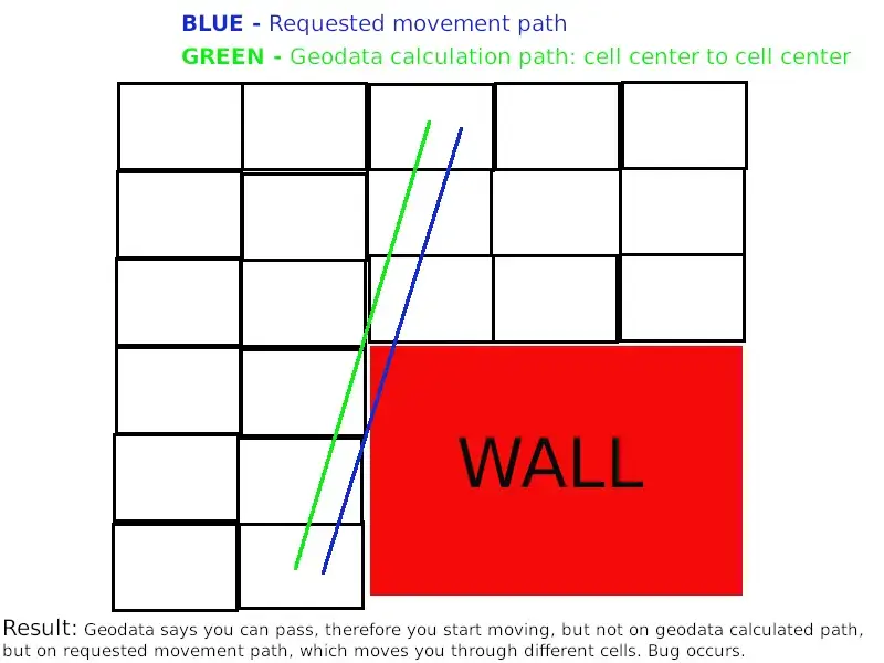
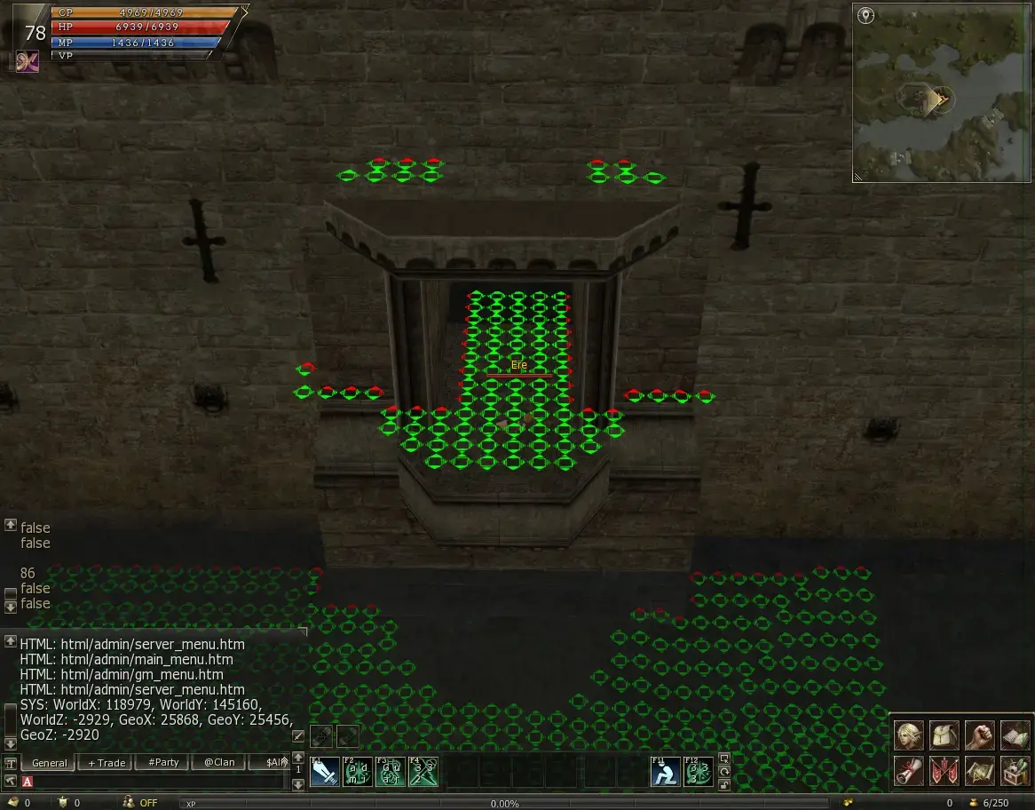
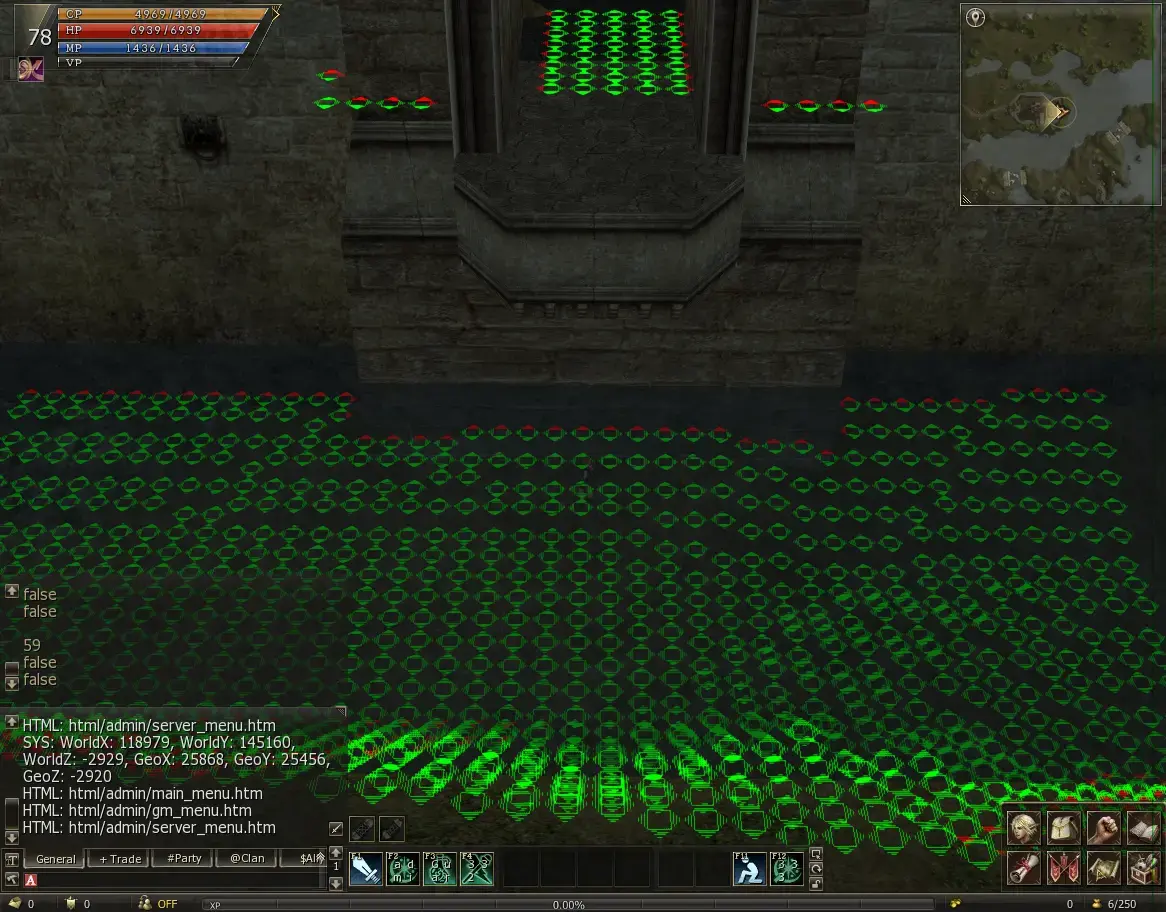
i tested giran castle with mobius geodata and devme geodata , i had ask him before many months to create me new geodata for castle ... the problem exist with mobius and devme geodata , so its 100% shit geo engine.Seems like the 2 bugs I am aware of, that make this happen, are present for you. The "water ignores geodata" and the bad geodata path calculation. I do not know how to proceed with this, as I need to dedicate a lot of free time. It is very likely that it might take a lot of work and testing.
Yes, as I explained before, the problem is not the geodata files, but the engine. The first problem (the Z jump) is caused by incorrect calculation of geodata path, which is present in the geoengine and the second problem is the "water movement ignores geodata", which is present in the movement system itself. Fixing the geodata engine is relatively less time-consuming, after all, it is 1 class file and easier to deal with. I've already delt with it before. The movement system on the other hand, is a whole hell on it's own. In other words, it took me 50 commits and 131 files changed over the span of a month.
Да нет там ничего сложного, это даже проще, чем найти детерминант матрицы 4x4, просто кто захочет тратить свое время на фикс шарных сборок. Кто хотел давно в своих приватных все сделалIt's tough. Almost nobody was able to fix geodata and movement issues for all of l2j's existence. To be fair, in my opinion, this is one of the most complex parts of l2j. It really does require some good programming knowledge, low-level programming and, most importantly, math and geometry! Not many programmers know math and geometry very well. And honestly, I am one of those people too.
I've only seen an improved movement system over vanilla l2jserver in "org.mmocore" servers (I dunno which pack this is, it is old source). And even there, it also had its fair share of small issues, like movement happening only from cell center to cell center. And if I recall correctly, spam-clicking to move there would cause your character to glitch.
For now I can only think of suggesting you to try and fix the geodata engine, then disable the water in the castle to prevent the "water movement ignores geodata" bug there, and hope for the best... But this is a temporary solution and will not fix the glitches and other "small" stuff. It can only "hopefully" fix the castle geodata problems and other related problems as "z jump"/falling though floors.
Извините, я не хочу обижать, но это звучит как ответ школьника, если честно. Просто очень плохо и без никакой добавленной стоимости. Вы хотите выразить себя, как будто вы делали это и вам всё понятно? Разве вы это делали? Если это факт, то я приношу вам мои извинения, мне будет очень интересно как вы подошли к этой проблеме. За столько лет я не увидел адекватного фикса, и в публичных и в приватных сборках. Мне тоже интересно кто из приватных сборок адекватно починил вся система передвижения.Да нет там ничего сложного, это даже проще, чем найти детерминант матрицы 4x4, просто кто захочет тратить свое время на фикс шарных сборок. Кто хотел давно в своих приватных все сделал
Да никаких обид. Я давненько изучаю архитектуру игровых движков и видел много людей, которые отлично разбираются в линейной алгебре и алгоритмах поиска пути. В шарных сборках l2 присутствует малая часть той математики, которая к тому же довольно скудно, криво и скучно реализована. Пока что я в своей сборке не переделал передвижение, но я писал свой 3д рендер с нуля без прилинковки каких либо библиотек, и хорошо знаю линейную алгебру, поэтому мне хватает знаний, чтобы сказать, что передвижение в шарных сборках л2 реализовано плохо. Вы написали, что не много программистов знают математику и геометрию. Это не так, довольно много программистов знают довольно много разделов математики, а про геометрию даже говорить не приходитсяИзвините, я не хочу обижать, но это звучит как ответ школьника, если честно. Просто очень плохо и без никакой добавленной стоимости. Вы хотите выразить себя, как будто вы делали это и вам всё понятно? Разве вы это делали? Если это факт, то я приношу вам мои извинения, мне будет очень интересно как вы подошли к этой проблеме. За столько лет я не увидел адекватного фикса, и в публичных и в приватных сборках. Мне тоже интересно кто из приватных сборок адекватно починил вся система передвижения.
Ну, например, я. Мой код не связан с мобусом и не основан на его коде. Мой геодвижок переписан практически полностью, умеет работать как с ПТС pathnode.bin, так и считает путь налету(и делает это лучше, лол) из файлов _conv.dat. Мной переписана модель движения как в воде и воздухе, так и по суше, включая вертикальную навигацию между слоями одного блока и сквозной поиск пути в 3D. В моей сборке есть встроенный редактор геодаты, который позволяет редактировать ее налету прямо из игры. Я писал некоторые статьи об этом тут и тут.Мне тоже интересно кто из приватных сборок адекватно починил вся система передвижения
Ну, вот что-то действительно интересно. Спасибо за статьи и видео. Внутриигровой геоедитор крутой. Я не трогал геодату, просто движок геодаты и систему передвижения. Поэтому мне интересно что вы писали и узнал больше о ней. Вообще когда я переделывал всё это, я думал, что геодата l2j не так уж и плоха и не кричит "исправьте меня!", как движок геодаты и система передвижения. Я больше работал над критичными багами и глюками. Вот как работает у меня, используя геодаты l2j. И да, есть ещё, что можно починить, но пока что, всё работает достаточно хорошенько.Ну, например, я. Мой код не связан с мобусом и не основан на его коде. Мой геодвижок переписан практически полностью, умеет работать как с ПТС pathnode.bin, так и считает путь налету(и делает это лучше, лол) из файлов _conv.dat. Мной переписана модель движения как в воде и воздухе, так и по суше, включая вертикальную навигацию между слоями одного блока и сквозной поиск пути в 3D. В моей сборке есть встроенный редактор геодаты, который позволяет редактировать ее налету прямо из игры. Я писал некоторые статьи об этом тут и тут.
Если чего-то нет в свободном доступе или в продаже, это не означает, что этого не существует в целом. И я знаю еще минимум 3 человек, которые сделали это лучше меня в своих приватных проектах)
PS: В НОРМАЛЬНЫХ приватных сборках качество и уровень реализации все же смогли выйти за границы 2009 года и отказаться от стандартов разработки того времени)))
look around, try to search a java server with fine geo-engine, which will meet your needs and rename topic or create a new one "looking guy, who can transfer geo-engine from source A to source B".I have no solution yet.. please someone skilled text me.
