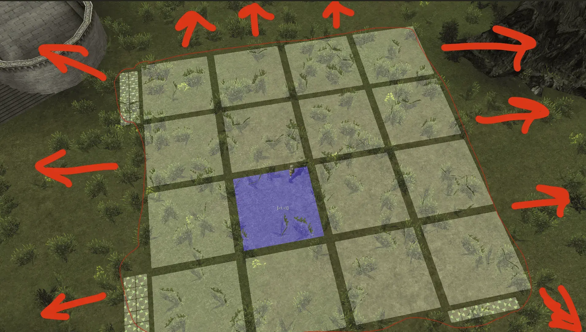
Could anybody tell me where the width and length of the ///geodata tiles is hard-coded in the client?
Установить приложение
Как установить приложение на iOS
Посмотрите видео ниже, чтобы узнать, как установить наш сайт в виде веб-приложения на главном экране.
Примечание: Эта функция может быть недоступна в некоторых браузерах.
Вы используете устаревший браузер. Этот и другие сайты могут отображаться в нём некорректно.
Вам необходимо обновить браузер или попробовать использовать другой.
Вам необходимо обновить браузер или попробовать использовать другой.
How to edit ///geodata range (width and length / number of tiles)?
- Автор темы Salty Mike
- Дата начала
Дополнительные настройки
Кто ответил?Интересует этот же вопросы где взять координаты xyz , в файлах геодаты ?Could anybody tell me where the width and length of the ///geodata tiles is hard-coded in the client?
В каком смысле? Если координаты гео-региона, то это 0 и 1 байты из файла геодаты.Интересует этот же вопросы где взять координаты xyz , в файлах геодаты ?
My question is not related to the XYZ coordinates.I'm interested in the same question: where can I get xyz coordinates in geodata files?
It is related to the width and length of the WHITE GRID which appears around the character when they use the ///geodata command with L2-OFF geodata files in the client.
How to display that ?expand display range of geodata cells in client (thats what he mean)
Посмотреть вложение 55181
Put you geodata files(*_conv.dat) at Client\System\GeoData\ folder, run client and type ///geodata as chat-commandHow to display that ?
Запрещено публиковать исходный код без BB-кода — CODE
Thank you so much Sir . I tried as you say ,put the files to the correct folder ,login Master account ,type command ,but it's not workPut you geodata files(*_conv.dat) at Client\System\GeoData\ folder, run client and type ///geodata as chat-command
console show :No handler registered for admin command 'admin_geodata'.
that's weird
<!-- ADMIN GEODATA -->
<admin command="admin_geo_z" accessLevel="7" />
<admin command="admin_geo_type" accessLevel="7" />
<admin command="admin_geo_nswe" accessLevel="7" />
<admin command="admin_geo_los" accessLevel="7" />
<admin command="admin_geo_position" accessLevel="7" />
<admin command="admin_geo_bug" accessLevel="7" />
<admin command="admin_geo_load" accessLevel="7" />
<admin command="admin_geo_unload" accessLevel="7" />
<!-- ADMIN GEO EDITOR -->
<admin command="admin_ge_status" accessLevel="7" />
<admin command="admin_ge_mode" accessLevel="7" />
<admin command="admin_ge_join" accessLevel="7" />
///geodataThank you so much Sir . I tried as you say ,put the files to the correct folder ,login Master account ,type command ,but it's not work
console show :No handler registered for admin command 'admin_geodata'.
that's weird
/ - triple slash
Yes ,Sir . I think maybe due to that server patch problem .you are good man ! thank you soooooooooo much !///geodata
/ - triple slash
Похожие темы
- Вопрос
- Ответы
- 3
- Просмотры
- 1К


